
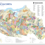
Franciacorta
12,00 €
NEW! The Geographical Units based on the Napoleonic Land Registry of 1807; detailed text on the back about the territory, climate and geology.
Product Description
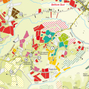
The world’s first map which offers the possibility of discovering, one by one, the production zones (Geographic Units) of this prestigious appellation based on the Napoleonic Land Registry of 1807.
Front:
The morphology of the territory with contour lines and altitude levels.
Indications of the main production zones and of the main place names.
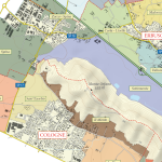
Back:
A in-depth description of the territory and of the appellation rules.
Simplified orographic map of the appellation.
Simplified geological map of the appellation.
Size: 59 x 84 cm (unfolded), 21×29,7 (A4 – folded)

Additional Information
| Weight | 0.06 kg |
|---|
Be the first to review “Franciacorta”
Related Products
-
Chianti Classico geological map
Categorie: Maps10,00 € Add to cart ViewThe first geological map of Chianti Classico, precise, thorough and most of all… clear!
-
Vino Nobile di Montepulciano
Categorie: Maps7,00 € Add to cart ViewThe world’s first map which offers the possibility of discovering, one by one, the estates and the most important viticultural zones of this prestigious Tuscan appellation. From Argiano to Asinone and from Cervognano to Caggiole, as always a unique and inimitable map in its precision and detail.
Reviews
There are no reviews yet, would you like to submit yours?